
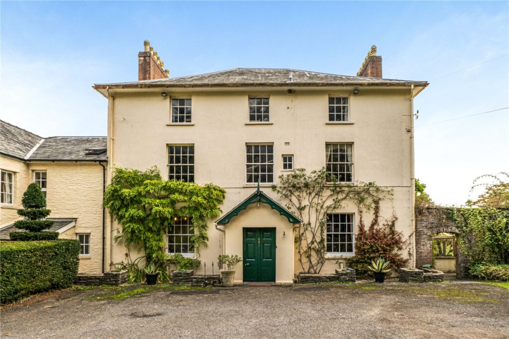
Talyllyn, Brecon, Powys, LD3 7SY

Source describes a productive growing area, a greenhouse, a workshop with the home. Selected for existing garden uses; owned plot size is unknown. Features and inclusion are agent claims, not verified title, boundaries or permissions.

Save

At a glance

Bedrooms
8
Land size
Useful garden; owned plot size unknown Source-reported
Location
Brecon, Powys
Home type
house
Tenure
Check with agent
Listing source
McCartneys ↗
The property particulars

Land, buildings and features

Agent-described

The agent describes the following features. Check what is included in the sale and their condition with the agent.

  • gardens at the home
  • a greenhouse or polytunnel
  • outbuildings
  • on-site parking
  • grounds at the home
  • paddocks or grazing
  • a workshop or studio
  • a productive growing area
  • a lake or substantial pondNearby; inclusion and access not established

From the agent’s listing, observed 2026-11-01 · Independently unverified · View original listing ↗

Further investigation

Using the land for a business

These are leads for further investigation. Rights, planning permission and business demand need separate checks.

Craft workshops and rural courses ↗

Physical characteristics worth investigating · Commercial permissions unknown

The source advertises a workshop or studio. This is an investigation lead; inclusion, condition, access and commercial permissions need separate checks.

Source / assessment date 2026-11-01 · Evidence source ↗

Location & getting there

Agent map pin

Brecon, Powys

The agency supplies this map point. The exact entrance has not been checked.

About this location

This is an advertised location, not a surveyed position or an ownership boundary. We have not measured its accuracy in metres. Confirm access and the entrance with the agent.

Location source ↗ · Observed 2026-11-01

Explore the surrounding landscape map with the 20 buyer questions ↓

Modelled road and railway noise

Noise mapping has not been verified for this property. An unavailable result is not evidence that the location is quiet.

Defra Round 4 modelling represents estimated 2021 outdoor transport noise at 4 metres above ground, not present-day levels or sounds inside the house. Results do not capture every nuisance, and the exact house position has not been confirmed. Night (Lnight) and weighted day-evening-night (Lden) metrics are different and should not be directly compared. An absent metric is unknown, not zero.

Travel times

Travel estimates are not available yet. A map pin alone does not confirm the driving entrance.

A field guide to this setting

20 questions about living here

Beyond the particulars: the things worth knowing before you buy a rural home. We show source-checked local mapping where we have it, and clearly identify the questions we cannot yet answer.

0 / 20questions with source-checked location data

20 questions still need local investigation. “Not yet assessed” does not mean safe, quiet, accessible or risk-free. The map is based on the agency’s approximate location, not a surveyed house boundary.

The surrounding area

Explore the landscape

Agent map pin

Explore mapped fields, woods, roads and paths around the agency's approximate pin. This is not a survey of the exact house, the owned land or legal walking access. Use the questions below to check what the map cannot establish.

Basemap © OpenStreetMap contributors (ODbL). Map features may be incomplete and do not prove public rights of way, flood safety or land ownership.

Landscape, peace and nature

01How quiet is it here, really?Not yet assessed

We do not have enough reviewed, location-specific evidence to answer this yet.

What to check: Visit at different times, including rush hour and evenings; listen for aircraft, industry, machinery and seasonal activities. Modelled road and rail noise cannot establish indoor quiet.

02How much nature surrounds this home?Not yet assessed

We do not have enough reviewed, location-specific evidence to answer this yet.

What to check: Check the actual habitats, woodland condition, land ownership and whether neighbouring countryside is publicly accessible. Mapped woodland is not the same as tree canopy or all natural land.

03Can I take long walks directly from the door?Not yet assessed

We do not have enough reviewed, location-specific evidence to answer this yet.

What to check: Trace connected public rights of way on the council's definitive map and check walking routes on the ground, including road crossings and seasonal closures.

Explore the approximate agency location on OpenStreetMap ↗ (orientation only, not proof of access or risk)

Official checks and supporting maps

04How dark will the skies be at night?Not yet assessed

We do not have enough reviewed, location-specific evidence to answer this yet.

What to check: Compare local night-light maps and nearby lit roads, towns and businesses, then visit on a clear moonless night.

05Which wildlife might I see locally?Not yet assessed

We do not have enough reviewed, location-specific evidence to answer this yet.

What to check: Check dated species records and nearby habitat records; sightings and habitat suitability do not guarantee wildlife at this property.

Risk, change and connectivity

06Is this location at risk of flooding?Not yet assessed

We do not have enough reviewed, location-specific evidence to answer this yet.

What to check: Check the appropriate national flood maps for river, coastal and surface-water risk, and ask about historic flooding and access-road flooding. An individual property survey may still be needed.

Official checks and supporting maps

07Could nearby activities bring smells or disruption?Not yet assessed

We do not have enough reviewed, location-specific evidence to answer this yet.

What to check: Look for working farms, livestock units, sewage works, quarries and landfill; ask locals about seasonal odours, dust and vehicle movements.

08Could a development change the view or peace?Not yet assessed

We do not have enough reviewed, location-specific evidence to answer this yet.

What to check: Search the local planning authority's current applications, planning history and adopted or emerging local plan. A quiet field today is not a guarantee of future views.

09Can I reach the home in winter or heavy rain?Not yet assessed

We do not have enough reviewed, location-specific evidence to answer this yet.

What to check: Check access-road gradients, width, winter maintenance, flood closures, alternative routes and whether the approach is publicly maintained.

Explore the approximate agency location on OpenStreetMap ↗ (orientation only, not proof of access or risk)

10Will broadband and mobile signal work here?Not yet assessed

We do not have enough reviewed, location-specific evidence to answer this yet.

What to check: Check address-level broadband availability, multiple mobile networks and indoor reception; confirm actual installation options before exchange.

Everyday practicalities

11How easy is it to reach essential services?Not yet assessed

We do not have enough reviewed, location-specific evidence to answer this yet.

What to check: Plan realistic journeys to a GP, pharmacy, supermarket, hospital, petrol station and emergency services; do not infer driving times from straight-line distance.

12Could I live here with fewer car journeys?Not yet assessed

We do not have enough reviewed, location-specific evidence to answer this yet.

What to check: Check the nearest usable bus stops and timetables, cycling safety, train services and how often public transport actually runs.

13Which schools are accessible from here?Not yet assessed

We do not have enough reviewed, location-specific evidence to answer this yet.

What to check: Check school travel routes, published admissions arrangements and latest inspection information. Proximity does not guarantee a school place.

14What geological or environmental risks exist?Not yet assessed

We do not have enough reviewed, location-specific evidence to answer this yet.

What to check: Review geology, historic mining, ground stability, radon and known contaminated-land records, with specialist searches where appropriate.

15Will the land suit gardening or keeping animals?Not yet assessed

We do not have enough reviewed, location-specific evidence to answer this yet.

What to check: Inspect soil, drainage, slope, aspect and exposure; check soil mapping and whether any land or animal use needs consent.

Space, recreation and future

16Where could I ride a horse nearby?Not yet assessed

We do not have enough reviewed, location-specific evidence to answer this yet.

What to check: Verify bridleways and byways on the definitive map, how they connect, road hazards and access to facilities. Footpaths alone do not grant horse-riding rights.

Explore the approximate agency location on OpenStreetMap ↗ (orientation only, not proof of access or risk)

17How private and secluded is the setting?Not yet assessed

We do not have enough reviewed, location-specific evidence to answer this yet.

What to check: Check neighbouring homes, public paths, overlooking, rights of access and actual sightlines from the land at different seasons.

18Which protected landscapes and special places are close?Not yet assessed

We do not have enough reviewed, location-specific evidence to answer this yet.

What to check: Check official National Park, National Landscape, reserve and designated-site boundaries, and whether each place is actually accessible.

Explore the approximate agency location on OpenStreetMap ↗ (orientation only, not proof of access or risk)

19What is everyday community life like?Not yet assessed

We do not have enough reviewed, location-specific evidence to answer this yet.

What to check: Look into village amenities, social groups, local services, community transport and recent changes; demographic summaries cannot describe every resident.

20How might this area change over the next 10–20 years?Not yet assessed

We do not have enough reviewed, location-specific evidence to answer this yet.

What to check: Review adopted plans, proposed infrastructure, land-use change and climate-risk projections. Long-range changes are scenarios, not certainties.

Source evidence

Recorded physical features from dated sources. Ownership boundaries and permitted uses are separate checks.

No individually verified physical features have been recorded yet. Ask the agent for the particulars and supporting plans.

What to verify before buying

Questions for your solicitor, surveyor and relevant professionals.

This checklist is for this visit. Save property notes in your private board.

Save to my board →